Top 5 best paragliding apps for your phone
Our tandem paragliding pilots select their favourite paragliding apps
We are using an ever increasing number of applications on our mobiles. Paragliding being a sport that requires careful planning, here too, numerous applications are dedicated to making pilot’s life easier.
This article was updated on 22/04/2024. We added an App recommendation in the “In-flight navigation” app and a new section: “Hike planning apps”.
In this article, we will introduce you to the best mobile apps available on Android and iOS for paragliding and free flight in general. Selected by our own pilots, we have chosen the most popular and useful applications for all everyone, whether you are looking for an easy top-to-bottom, a nice Hike & Fly or planning an epic cross! We’ve also included information about each app’s features and how they can help you improve your flying.
- Weather apps
- Flight planning apps
- In-flight navigation apps
- Flight analysis app
- Apps and services to log and display your flights
- Hike Planning apps
Weather apps
Meteo Parapente
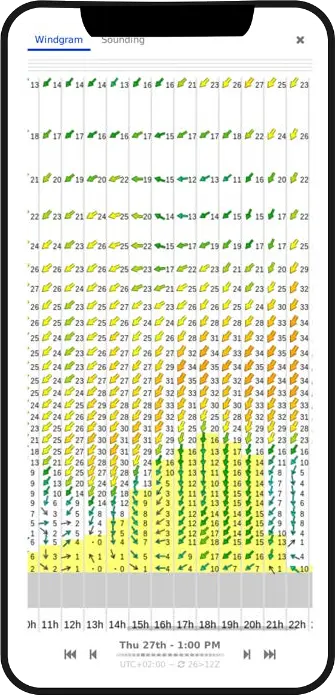
This application is probably the most used by paragliding pilots. Especially in France where everybody seems to be consulting it before any serious next day planning.
It presents, without frills, the altitude of cloudbase and the wind speed by hour and altitude level for any paragliding spot in the world. A heavily simplified emagram to visualise likely thermal activity is also easily accessible under the “sounding” tab for any paragliding spot per hour.
Created by Nicolas Baldek, it is available for free on computer for “today”. For the following days on computer and, as of recently, for mobile access, a payment of 36 € / year (or 24 € / year in student rate) is needed.
Being able to visualise so easily such vital information when planning your flight just by browsing a map is definitely worth it!
Other notable apps
Windy.com : is a general-purpose app that still provides detailed coverage for paragliding pilots. It offers numerous features, including the ability to view multiple layers of information on the same map for example mapping wind direction and wind strength or cloudbase altitude and weather radar, for example. The app also offers to compare different weather models if you want to dig deep or you know that the GFS model, for example, is more accurate than ECMWF for your given location.
Disponibilité : Android / iOS / Web
meteoblue : This app is accessible for free with ads. It offers a very comprehensiv set of features and is very popular. Forecasts is offered up to 7 days in advance, weathergrams, satellite, radar imagery, as well as a 3-day wind map is also available to display. Meteoblue uses its own weather model and combine it with those from third parties (such as GFS22, COSMO2, and AROME2) offering a full picture.
Available on: Android / iOS / Web
Meteo Annecy : a special mention for this application by Météo Villes. It covers Annecy but also other cities in France and Europe. It is a generalist weather app extremely accurate for Annecy, providing a strong overview for the Lake Annecy region before a deep-dive using paragliding specific apps. The service is curated by professional and provide in-depth broader longer term analysis. The ads can be obtrusive at time, even better a reason to upgrade.
Available on: : Android / iOS / Web
Flyeo shop clearance
Flight planning apps
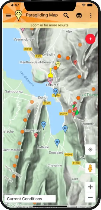
Paragliding Map
The most comprehensive application for finding paragliding sites worldwide, including extensive information on how to access them, recommendations for flying them, and weather conditions at the site. The app aims to answer easily the question: is it flyable?
The free version provides access to paragliding sites’ profile and includes what wing direction it takes as well as the current weather condition.
The paid version, starting at €3.99 per month, provides access to a multitude of features; including a three-day weather view provided in collaboration with various reputable providers (including meteoblue), as well as a 3D view that shows paragliding spots and how to approach them when hiking. It’s the perfect app for planning a hike-and-fly or cross-country flight!
Other notable apps
Spotair : This application lays out on a map various types of information such as live weather stations reports, live cameras video feeds, rain radar, etc.. Pilots can identify paragliding spots in real-time and appraise whether they are flyable. Spotair also attempts to provide feedback from real users. Anyone can create a “Shakas”, essentially comments that summarise the conditions on site and confirm what is reported by the weather station. “Thumb up”, “it’s flyable” and so on can be displayed for instant validation before you pack your wing..
Available on: Web app only
In-flight navigation apps
XC Track
Cross-country enthusiasts of all levels swear by this application, whether during competitions or their day-to-day flights since the app allows you to set up waypoints in order to plan your long-distance flight and then follow when you are in the air.
The screen is fully customisable according to your one’s goals and preferences. While configuring the app can be a bit complicated, since the app is open-source, there are numerous forums and resources available online if you are stuck. Special mention for this excellent friendly English speaking Telegram channel dedicated to XCTrack where someone always has an answer to your configuration problem…
Additionally, it is possible to import pre-made configurations. So, don’t hesitate to borrow your friend’s config; it will save you time.
We also recommend this highly detailed manual provided by Air3, a company that makes flying instruments using XCTrack as their nav software.
It is worth noting that this app is quite battery-intensive, so it is advisable to bring an external battery pack or to lower your phone’s brightness. Tracks are recorded on your mobile device. It is also possible to activate live tracking to share your flight in real-time with friends!
Available on: Android only
Other notable apps
TheFlightVario : Not 1 but 3 apps. TheFlightVario provides three free apps for navigation: XC Vario, Classic Vario and Basic Vario provides ready made views adapted to each pilot needs. All apps relie on IMU (a mix of all sensors available on modern phones) rather than the sole bariometer sensor. Full explanation on IMU Vs Bario here.
Available on: Android only
Flyskyhy : There aren’t many flight navigation apps available for iOS. Flyskyhy is an exception. This paid app (€8.99 + in-app purchases) and deserve a mention.
Available on: iOS only
SeeYou Navigator : Available on both mobile platforms, this app is made by flight instrument manufacturer Naviter. SeeYou is incredibly user-friendly since it comes fully configured right from the start. However, it’s important to note that it is only available with a paid subscription to the Naviter SeeYou suite. Our friend at Cross Country magazine have a full review of the SeeYou app if you want to find out more about what it’s like.
Available on: Android / iOS
Flight analysis apps
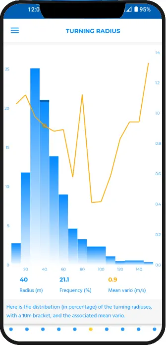
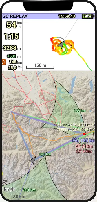
XC Analytics
Singular: to our knowledge, there is only one app available for Android to analyse flight data.
XC Analytics reads your IGC files which are produced by navigation apps (such as XC Track or See You Navigator mentioned above). It then analyses them to provide you with statistics and recommendations tailored to four specific flight phases: Lift, Gliding, Floating and Prospecting. The idea is to help you fine tune each phase to the in order to become an overall better pilot.
Across 8 categories, XC Analytics produces 63 distinct flight stats represented on 34 graphs to dissect your flight log. It is also possible to compare two flights in parallel. In short, it is a treasure trove of information to dissect your flight.
Available on: Android only
Apps to log and display your flights
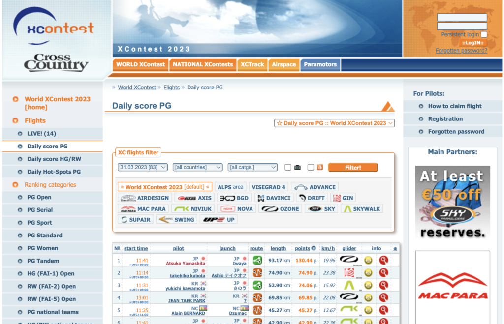
XContest
Not an app exactly per se since it is a website to list flights. And it could also figure in the flight analysis or flight planning sections too.
XContest is the global flight logbook for all cross-country flights carried out by pilots who want to compare their performance with that of their peers. This website allows you to log your personal flights, view similar flights that have been made on a given route, or compare your cross-country flights with those of all pilots who log their flights. In short, it’s an encyclopedia of flying routes. Yes, you can see whether you fly longer and further than your mate, but it is also super powerful to plan a flight by following other people trace.
It’s worth noting that most in-flight apps such as the ones mentioned above integrate with XContest to send flight log to it as a push of a button..
Available on: Web only
Other notable services
Air Tribune : This online service has a similar offering to XContest, although it is much more competition-oriented. It is often the tracking service used for official paragliding competitions.
Journal de Vol : Still in development, this service allows you to visualize your flights in 3D, discover new sites, and participate in challenges. With features like flight plans, trophies, wind rose, and flight planning assistance, this website, created in 2019, aims to be highly comprehensive.
Apps to plan your hike to take off
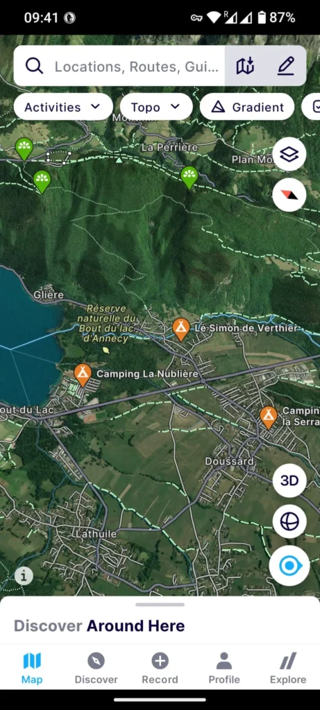
Fatmap
If you are into Hike & Fly, and an increasing number of pilots are, you need to get to Take off on foot before taking to the air. Fatmap is a fantastic app to help you doing just that.
The free version gives you the ability to see a 3D zoomable app with all the paths available, hiking routes already people followed as well as record your tracks and report on key stats.
It is however limited and require an internet connection to work. Paying for the Premium version unlock a world of additional options, including offline navigation and many more features. You can even pay a monthly supplement to add IGN ma views for example.
Fatmap was acquired by Strava a couple of years ago.
Other notable app
AllTrails : Another trail app with a similar feature set but much more complete in its free version. You can view available hikes to follow, have full offline access to the map and can also log and share your own hikes. There is however very little customisation of the default map layer.
Available on: Android / iOS